Join us on Saturday, April 20 from 10 am-12 noon … [Read More...] about Annual Meeting of the Friends for the Abbott Marshlands
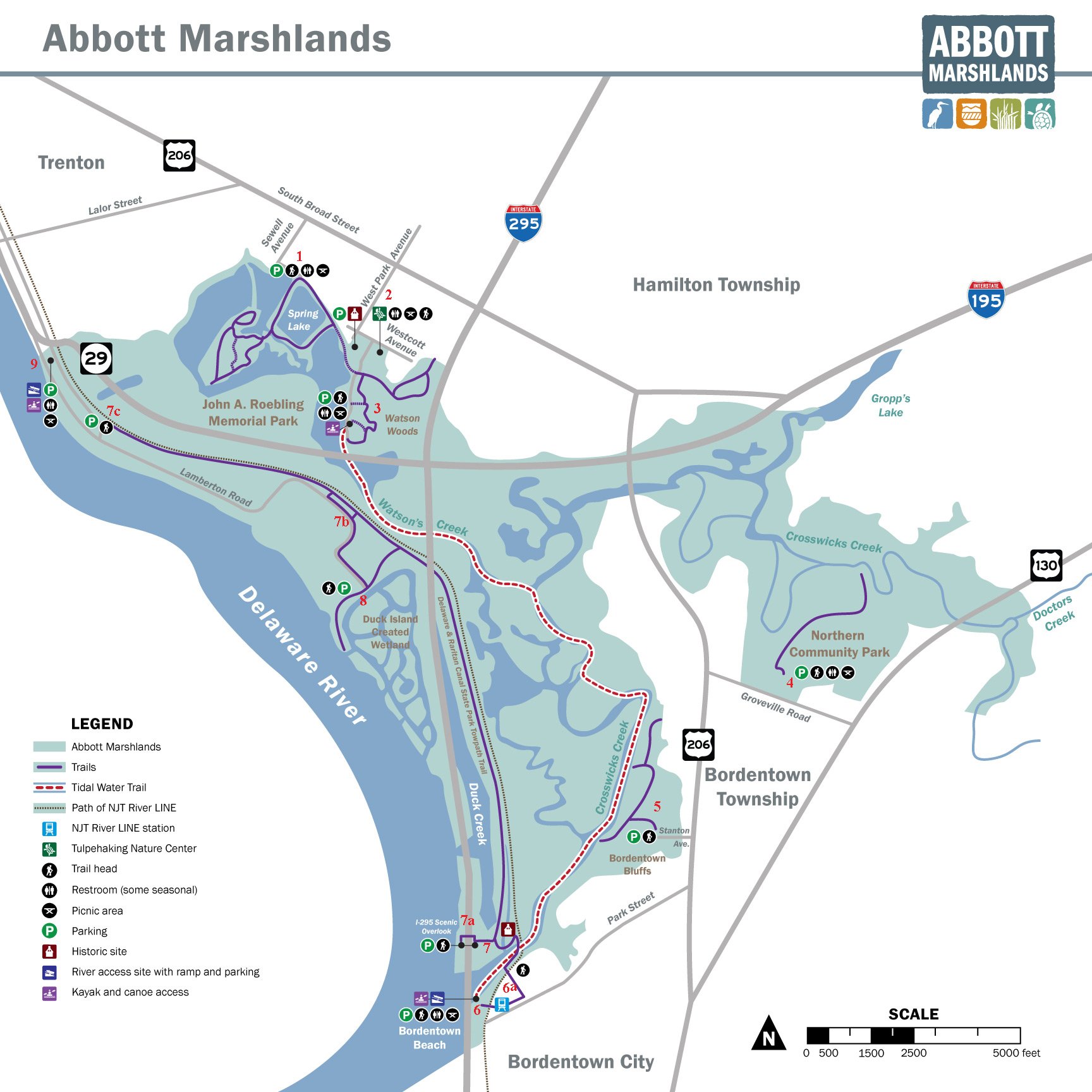
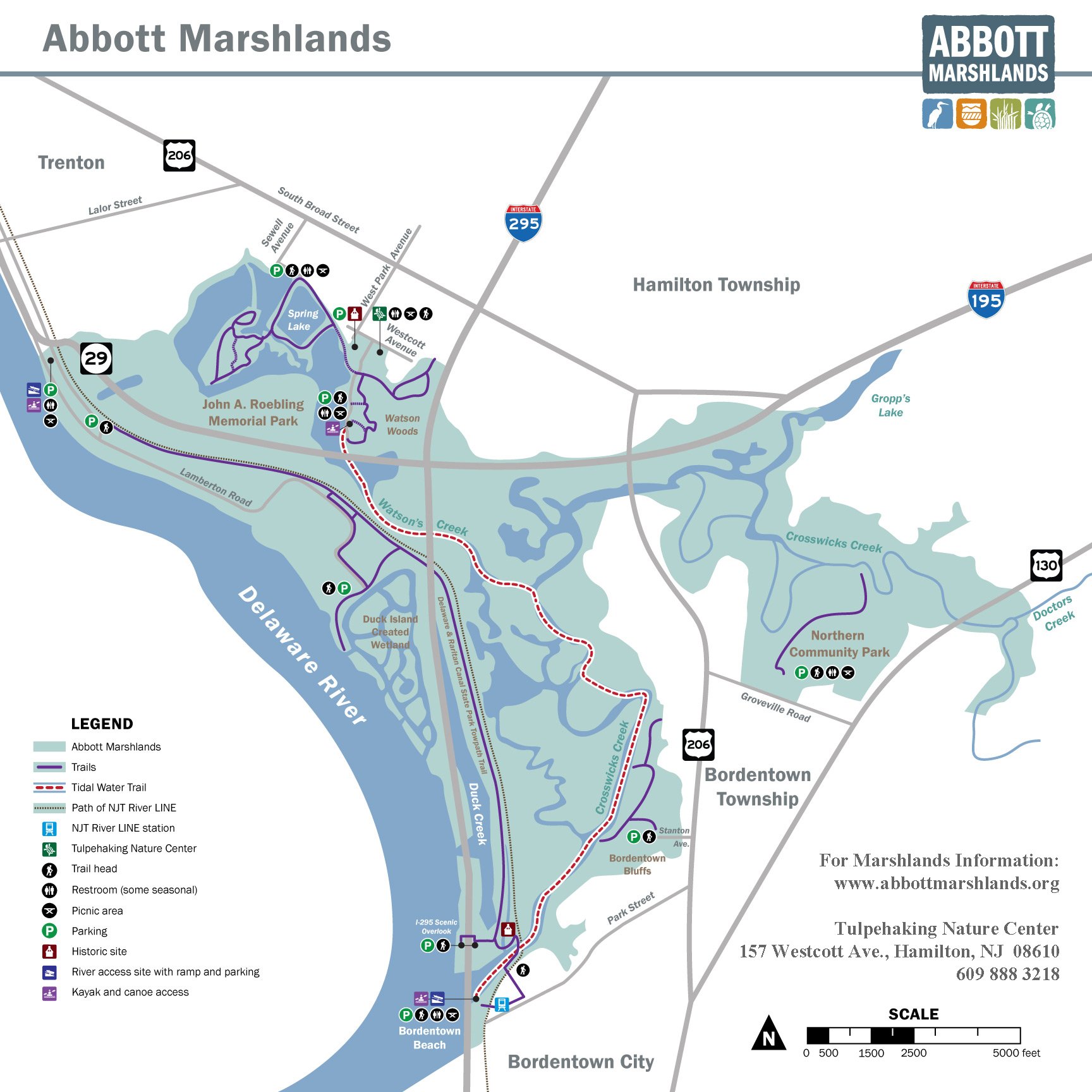
Trail Access / Parking Areas
There are a number of easily accessible trails and parking areas within the Abbott Marshlands. Please refer to the numbered locations on the map and find their corresponding descriptions and directions below.
Notes:
Please note that bicycling is allowed only on the trail around Spring Lake (1) and on the D&R Canal Tow Path Trail (7). Other trails are too fragile. The NJ Transit Light Rail station (6) provides easy access via public transportation. For Tidal Water Trail Access see Watson Woods (3) and/or Bordentown Beach(6). Motorized vehicles are not permitted on any trails.
Trails
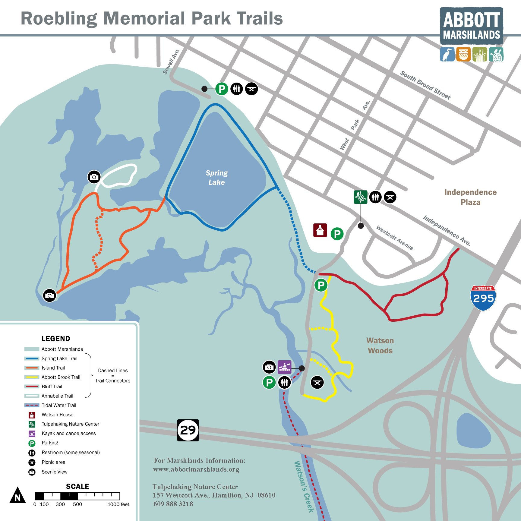
1. Spring Lake at Roebling Park
2. Tulpehaking Nature Center
3. Watson Woods at Roebling Park
1. Spring Lake at Roebling Park
(Hamilton Township) (get directions)
GPS Coordinates: N40 11.714 W74 43.923For 8″x8″ map, for full size map.
What to do: Hiking, Picnicking, Canoeing
Biking only around Spring Lake and to/from Watson Woods, Tulpehaking Nature Center.
For more information: http://www.njtrails.org/trailguide.php?TrailID=42
Additional Directions: From South Broad Street turn West onto Sewell Ave. The closest intersection to the park is Sewell and McClellan. Continue past McClellan to the end of Sewell, turn left and drive down the hill to the parking lot.
2. Tulpehaking Nature Center
157 Westcott Avenue, Hamilton. Please do not park on Westcott Avenue. (get directions)
GPS Coordinates: N40 11.482 W74 43.564
Parking is near the Watson House.
From this location, there is access to both Spring Lake (1) and Watson Woods (2) trails.
For 8″x8″ map, for full size map.
What to do: see calendar for programs. There are displays and exhibits on view. Hours: Friday, Saturday 10 am – 4 pm; Sunday noon- 4 pm.
For Hiking, walk or drive down hill to Watson Wood and Spring Lake trails.
Additional Directions: From South Broad St. turn west onto West Park Ave. The closest intersection to the park is West Park Avenue and Westcott Avenue. Turn left onto Westcott Avenue and then right at the sign into Roebling Park. Parking for the nature center is the lot near the Watson house, on the right just before the road descends downhill. Across the road from the parking area, there is a metal bench near a path leading to the nature center, which has a new yellow addition.
3. Watson Woods at Roebling Park
Hamilton Township (get directions)
GPS Coordinates: N40 11.171 w74 43.674
What to do: Hiking, Picnicking, Canoeing
Biking only to/from Watson Woods, Tulpehaking Nature Center and around Spring Lake.
For 8″x8″ map, for full size map.
For Tidal Water Trail, 8″ x 8″ map, for full size map.
For more information: http://www.njtrails.org/trailguide.php?TrailID=21
Additional Directions: From South Broad Street, turn west onto West Park Avenue. The closest intersection to the park is West Park Avenue and Westcott Avenue. Turn left onto Westcott Avenue, and then right at the sign, into Roebling Park. Drive past the Watson House, proceed to bottom of hill and continue to parking, hiking trails, picnic tables, and Watson Creek boat launch area.
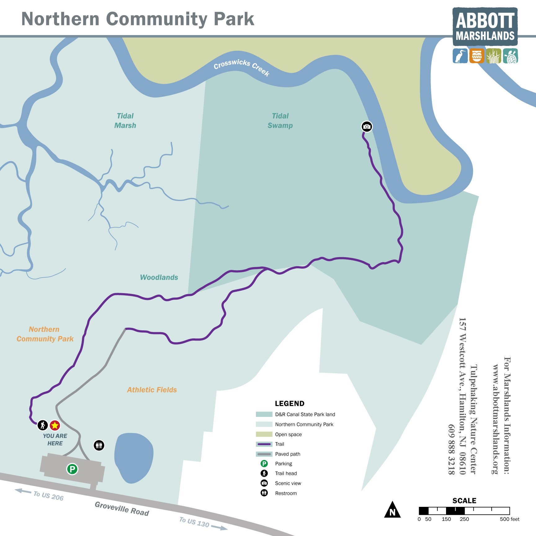
4. Northern Community Park
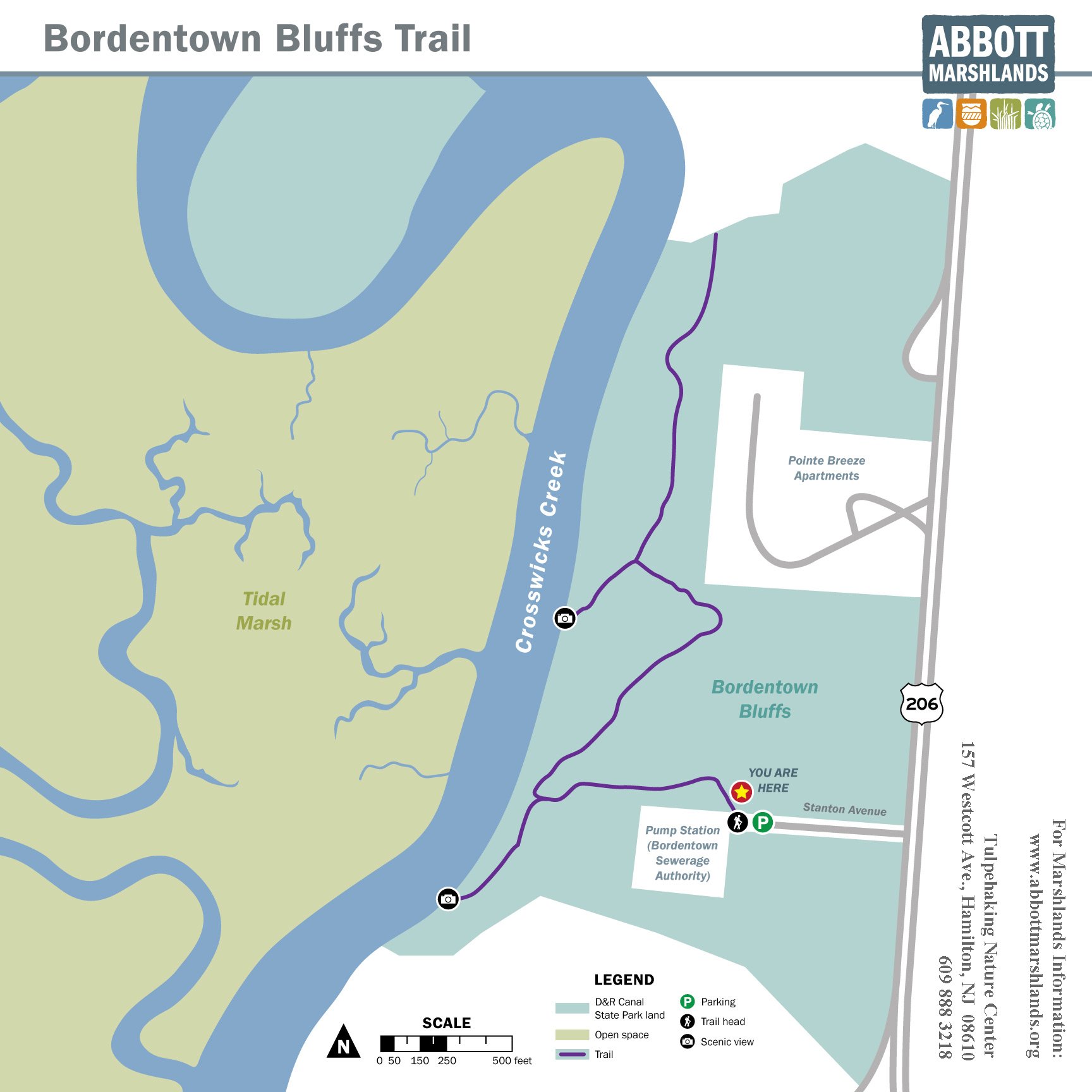
5. Bordentown Bluffs / D&R Canal State Park
6. Bordentown Beach
4. Northern Community Park
Bordentown Township (get directions)
GPS Coordinates: N40 10.276 w74 41.532
For 8″x8″ map, for full size map.
What to do: Hiking, Picnicking
For more information: http://www.njtrails.org/trailguide.php?TrailID=43
Additional Directions: Northern Community Park is located on Groveville Road between Route 206 and Route 130. Groveville Road is accessible from northbound Route 206, and Route 130 in Bordentown Township. These are the closest major intersections.
5. Bordentown Bluffs / D&R Canal State Park
Bordentown Township (get directions)
GPS Coordinates: needed
For 8″x8″ map, for full size map.
What to do: Hiking
For more information: http://www.njtrails.org/trailguide.php?TrailID=22
Additional Directions: This access point is accessible from Route 206 South in Bordentown Township, south of the I-195 interchange. From Route 206 South, turn right onto Stanton Avenue, which is the first right past Pointe Breeze Apartments. The Stanton Avenue street sign may be missing. Please do not park in front of either gate.
6. Bordentown Beach
(get directions) and Tidal Water Trail
GPS Coordinates: N40 08.867 W74 43.102
What to do: Picnicking, Paddling.
For Hiking, take bridge over Crosswicks Creek to the Tow Path Trail; see map: 8″x8″ map, for full size map.
For paddling and access to the Tidal Water Trail: for 8″ x 8″ map, for full size map.
Additional Directions: From Route 206, take Park St. west into Bordentown. Park Street eventually becomes West Park Street; the closest intersection is Prince Street and West Park Street. From there continue down hill to the banks of Delaware River and Crosswicks Creek. The beach is also accessible by Light Rail; .
6a. NJ Transit Light Rail Station. Use the Bordentown City stop. From here you can visit the Bordentown Beach and walk to the D&R Canal Towpath Trail. For 8″x8″ map, for full size map click here.
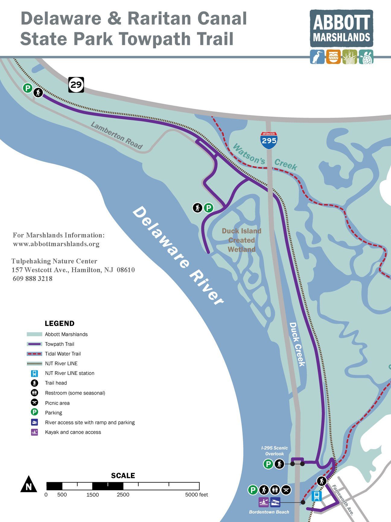
7. D&R Canal State Park Tow Path Trail
8. Duck Island. Created Wetland
9. Trenton Boat Launch
7. D&R Canal State Park Tow Path Trail
Hamilton Township
What to do: Hiking, Bicycling. Fishing is permitted on the bridge over Crosswicks Creek.
For 8″x8″ map, for full size map.
7A. I-295 Scenic Overlook (get directions)
GPS Coordinates: N40 09.257 W74 43.049.
Additional Directions: Trails are accessible from the Scenic Overlook on the Northbound Side of I-295, north of Bordentown. From southbound I-295, park at the Scenic Overlook and cross the pedestrian bridge over the highway to the northbound parking lot. From the parking lot, take the stairs (south end of lot) or ramp leading down to the trail. Follow the trail; after a short distance it will bear to the left, eventually reaching an intersection with the tow path. Turn north (left); the trail goes north 3 miles along the D&R Canal to Canal Boulevard* near Lamberton Road. The canal here is tidal.
If you turn south (right), you will shortly reach a restored bridge over Lock 1 of the D&R Canal.
7B. Three Branch Trails can take you to the Delaware River. See Towpath Trail map. ‘Connector’ Trail is the southernmost one and takes you directly to parking at the south end of Lamberton Rd.
7C. North parking – Lamberton Road access (get directions)
GPS Coordinates: N40 11.109 W74 44.793
Additional Directions: This location is accessible from Route 129 South or Route 29.
-
-
-
-
-
- From NJ 129 south take the Lamberton Road exit; you will first be on Canal Boulevard. Follow Canal Boulevard past Sturgeon Pond; after the road curves to the right, look on the left for a gate with small brown Park sign. If you reach Lamberton Road you’ve gone too far. Park on the shoulder of the road, near the gate. Don’t block the gate. Walk around the gate to the trail; it is It 3.3 miles via the trail to the I-295 Scenic Overlook (7 A and 7 B).
- From Route 29 South, take the Duck Island/Lamberton Road exit. Turn left at Canal Boulevard. After a short distance look on the right for a gate with a small brown Park sign.
- From Route 29 North, take the Duck Island/Lamberton Road exit. You will first be on Canal Boulevard. Follow Canal Boulevard past Sturgeon Pond; after the road curves to the right, look on the left for a gate with small brown Park sign. *Note: On some maps Canal Boulevard is called Lamberton Road Connector.
-
-
-
-
8. Duck Island. Created Wetland
Hamilton Township (get directions)
GPS Coordinates: N40 10.528 W74 43.581
For 8″x8″ map, for full size map.
What to do: Hiking, Fishing
Additional Directions: This location is accessible from Route 129 South or Route 29.
- From NJ 129 south take the Lamberton Road exit; you will first be on Canal Boulevard. Follow Canal Boulevard to a t-intersection; turn left onto Lamberton Road. Drive more than 1 mile, passing PSE&G and oil tanks. Park in the parking area at the very end of the road. If you are facing the fence (south), toward the right (west) is a short trail out to the Delaware River.
- From Route 29 South, take the Duck Island/Lamberton Road exit. Follow Lamberton to its end, passing PSE&G and oil tanks along the way.
- From Route 29 North, take the Duck Island/Lamberton Road exit. You will first be on Canal Boulevard. At a t-intersection, turn left (south) onto Lamberton Road. Follow Lamberton Road to its end, passing PSE&G and oil tanks along the way.
*Note: On some maps Canal Boulevard is called Lamberton Road Connector.
9. Trenton Boat Launch
1589 Lamberton Road (get directions)
What to do: Picnicking, Canoeing, Fishing
GPS Coordinates: N40 11.196 W74 45.205
Additional Directions: This location is accessible from Route 129 South or Route 29.
- From NJ 129 south take the Lamberton Road exit; you will first be on Canal Boulevard. At a t-intersection, turn right onto Lamberton Road. The Boat launch is a short distance north on the left.
- From Route 29 South, take the Duck Island/Lamberton Road exit. Once on Lamberton Road, go past the Trenton Marine Terminal. The launch area will be a short distance further on your right.
- From route 29 North, take the Duck Island/Lamberton Road exit. You will first be on Canal Boulevard. At a t-intersection, turn right onto Lamberton Road. Once on Lamberton Road, the launch area will be on your left.
*Note: On some maps Canal Boulevard is called Lamberton Road Connector.
TravelStorys: Try our self-guided tours of the Abbott Marshlands using the TravelStorys App Walking the Abbott Marshlands & Paddling the Abbott Marshlands
NOTICE: Neither Friends for the Marsh, D&R Greenway Land Trust, or other organizations or individuals mentioned in this website are responsible for injury, loss of property, or other events that might occur on a visit at the Abbott Marshlands.
Remember:

Green Darner © Herb Lord Please walk on trails. The marsh is a fragile resource. Trampled plants may not recover.
- Please note that trails may be slightly rerouted due to downed trees. Trails have been marked using plastic arrows instead of blazes (paint).
- When canoeing or kayaking, take care in tidal areas; currents may be fast, forceful, and dangerous, and the water deep. Wear a life vest at all times. Take guided trips if you are an inexperienced paddler. Except for Spring Lake, waterways are tidal. For tide information see local newspapers or Tides on this website.
- Please follow canoe / boating courtesy rules when you paddle. See www.americancanoe.org, then click on Learn To Paddle, then click on Top Five Tips; or http://dnr.wi.gov/org/caer/ce/eek/nature/camp/canoesafety.htm. Large boats that are difficult to turn have the right of way.
- Don’t forget to check for ticks that can be active any time of the year. Also take care to prevent mosquitoes from biting.
- Please report downed trees and other trail impediments to [email protected].
- Be mindful that this natural area is located in an urban setting. Use caution when visiting. Don’t leave your camera or valuables lying about. Report any suspicious behavior to the Hamilton (609-581-4000) or Bordentown Township (609- 298-2800) Police. In an emergency, call 911.
Footer
Search
News
Apply Now for Summer 2024 Jack Graham Internships
The Friends for there Abbott Marshlands are … [Read More...] about Apply Now for Summer 2024 Jack Graham Internships
